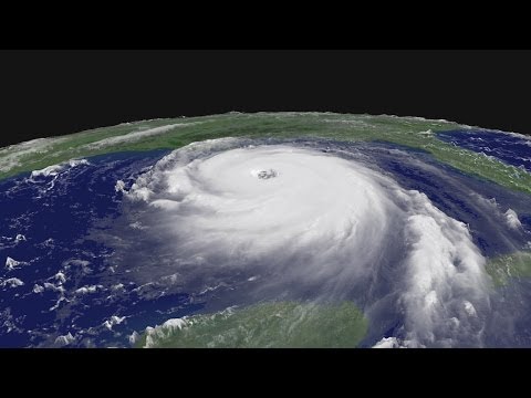
Subtitles section Play video Print subtitles Hurricanes. Typhoons. Cyclones. They are creatures of tropical seas, sweeping up heat laden waters, converting it to wind, rain, and waves. Why do a rare few evolve into colossal monsters that leave in their wake a trail of destruction, death, and despair? Do we now face a rising tide of Super Hurricanes and Typhoons? For millennia, we saw the oceans as mysterious wellsprings of natureÕs power. Capable of rising up and engulfing us. In William ShakespeareÕs drama, The Tempest, a shipÕs crew faces a sudden maelstrom, as dramatized in the 2010 Julie Taymor film. Unknown to the crew, the storm was conjured by a would be ruler turned sorcerer. The story is said to have been inspired by a storm that sent the English flagship Sea Venture onto Bermuda shoals in the year 1609. ItÕs now one of many shipwrecks that litter tropical sea bottoms. So too, the history books are filled with stories of cities and towns caught off guard by the sudden onrush of a tropical storm. Among the worst, Galveston, Texas, September 1900. With swells beginning to rise on September 7th, officials issued a hurricane warning. A ship at sea estimated the winds in the approaching storm at 100 miles, or 160 kilometers, per hour. As powerful as the storm was, little was known about it, including where it would hit and how bad it would be. By 5:00 PM, hurricane force winds began to pound the beaches of Galveston. By the time the hurricane came ashore that evening, its winds had risen to 217 kilometers per hourÉ a category four on todayÕs five-point Saffir-Simpson scale. In what is still to this day the deadliest natural disaster in American history, 8,000 lives, 20% of the islandÕs population, were lost. The city of Galveston was reduced to rubble by wind-driven waves and tides, called storm surge, that rose to over 5 meters. Hurricanes, also called cyclones or typhoons, are giant rotating storms that feed on solar heat captured by tropical oceans. A rare few, like the one that hit Galveston, go beyond the norm, to marshal the extreme power of the seas. In 1969, weather satellites showed hurricane Camille bearing down on the Mississippi coast. ItÕs now six-thirty pm in Biloxi, Mississippi and the hurricane is really beginning to be felt here. As you can see the palm trees are blowing, the rain is beginning to increase, and the sea is beginning to churn in the Gulf. It promises to be a long, long night in Biloxi. The storm intensified suddenly as it hit land with category five winds of over 300 kilometers per hour, and a storm surge that reached 8 meters high. Camille wrecked the coastline and drowned 143. Sweeping inland, it brought floods to the mountains of Virginia that killed another 113. Ironically, just as Camille headed for landfall, scientists flew out to Hurricane Debbie to perform the last in a series of experiments designed to bend back NatureÕs power. The idea of the project, called Stormfury, was to load up an airplane with silver iodide crystals. Flying around the periphery of a storm, they would spread the crystals around in hopes of stimulating new cloud formation, and in so doing steal the energy flowing into the eye. The idea was never proven to work. We now see hurricanes, typhoons, and cyclones as the product of climate systems on a much larger scale, water and wind, oceans and land. They are fueled by heat from the sun, captured and stored in the upper layer of tropical oceans. The deeper and warmer this upper layer becomes, the stronger and longer lasting a hurricane can be. In the Atlantic ocean, they often begin their lives over mountains in East Africa. As the wind sweeps over them, an area of low pressure forms. It tavels across the Sahara Desert, then moves out over the warm Atlantic. There, it can spawn thunderstorms over a broad region. As the low gradually comes under the influence of the EarthÕs rotation, called the coriolis force, it begins to spin. As the storm intensifies, the pressure in its center continues to drop, forming whatÕs known as the eye. It acts like a partial vacuum, causing winds at the sea surface to spiral inward toward it. These in-spiraling winds evaporate moisture from the warm ocean surface. As they near the eye, they veer upward, producing clouds and rain. Much of this air moves outward at the top of the storm, like a chimney. Some flows back down into the center, causing the eye to dry out and become clear. The path a hurricane takes, and the intensity it reaches, are determined by its interaction with global weather systems and ocean currents. In most cases, they form in vast ocean areas along the equator, pushed along by equatorial wind currents. At higher latitudes, to the north and south, east-bound winds circle the globe. Where they converge in the tropics, the flow shifts to the west, forming the trade winds and a band of precipitation called the Intertropical Convergence Zone. Stretching all around the Earth, this is the breeding ground for countless thunderstorms and larger tropical storms. The moisture they stir up often flows toward the poles, drawn by great spiraling weather systems to the north and south. When the tropics flare up, a fleet of satellites monitors the activity and sends down a wealth of data about the state of the oceans and the atmosphere. Meteorologists tap into a network of buoys and ship reports to monitor ocean temperatures, wind, and wave heights, on the hunt for conditions that favor hurricane development. From all this data, meteorologists have improved their ability to forecast the twists and turns of a hurricaneÕs path. As a result, few are caught by surprise, from shipping companies to coastal businesses, local and state governments, and the public at large. And yet the challenge of protecting life and property is only getting worse. Lately, scientists have been computing the risks, and running the probabilities, of a terrible growing conflict between humans and nature. Quite simply, more and more people are moving to coastlines around the world, drawn by a combination of jobs and lifestyle. In the United States, for example, 39% of the population lives in coastal counties. A Columbia University report takes a global look at this trend by identifying major disaster hot spots. Bangladesh. The Philippines. The east coast of China. The east coast of North America. To make matters worse, the oceans have gotten steadily warmer over the last few decades, adding potency to the hurricaneÕs fuel. Sea levels are expected to rise by as much as a meter by the end of the century, increasing the risks of storm surge. As more people pack the coastlines, man and nature are in the midst of an excrutiating head-on collision. Hurricane Ike slammed into Galveston in 2008. The cost in 2010 dollars: 28 billion. Andrew hit Miami in 1992. 45 billion. Sandy swept into New Jersey in 2012. 60 billion. Katrina in New Orleans: 106 billion. Not to mention the loss of thousands of lives. To help communities prepare, hurricane scientists are working to improve their ability to predict changes in a stormÕs intensity: to find out whether it will fizzle, bringing only wind and high surf, or become a destructive monster. As large as a hurricane is, its behavior is subject to subtle shifts in wind and ocean currents, the presence of land masses, and the interaction of all the clouds and water molecules and even dust within it. Scientists are zeroing in on a few key diagnostics. One of these is the warmth of the ocean out ahead of the storm, the fuel that feeds a hurricane. Because hurricanes draw water up from the deep, a warm and thick surface layer is crucial for the storm to reach high intensity. When hurricane Katrina entered the Gulf of Mexico in 2005, it encountered a wide and deep tongue of exceptionally warm water that originates in the Caribbean, called the loop current. As Katrina moved over this current, its winds picked up speed, reaching 281 kilometers per hour, category five status. A series of individual storms literally exploded close to the eye, visible in this sequence of satellite images. This often happens when the eye of the storm, the central region, contracts, getting smaller. As the storm spins up, the winds moving around the eye accelerate. Eddies, or vortices, begin to develop. These whirling winds evaporate large volumes of moisture from the ocean surface. That feeds the clouds, and causes them to shoot to high altitudes. Because these clouds can be spotted from satellites, they are a sign that things are heating up. These are photographs of the central, clear eye of Hurricane Katrina, taken by researchers who flew into it. From this vantage point, a hurricane is a beautiful architecture of the skies, built from clouds that have erupted from the sea like bombs. Their rise coincided with a fierce battle that had begun to develop deep within the storm. In this satellite image, a microwave beam was used to slice through Katrina at the point of maximum intensity. Storms were rising all around the hurricane. In radar images since the 1980s, scientists have seen that even as a tight, clear eyewall forms, conditions can be so favorable for hurricane development that a second eyewall forms around it. That steals some of the inflowing air and causes the inner eyewall to fade away. The outer eye then contracts, forming a new inner eye. Through this process, strong hurricanes can go through cycles of weakening and intensifying. You can see it happening in Katrina as it moved across the Gulf of Mexico. In this radar image, Katrina was rated a category five, as winds raced around its relatively small eye. While the central eyewall remained intact, storm development on the periphery began to sap its energy. Entering cooler waters along the coast, it ramped down to a category 3. Even then, wind driven waves breached levies that had been built to protect New Orleans, and flooded the city. But not all destructive storms fit this mold. Hurricane Sandy was a rare late October storm rated category 1 as it moved up the Atlantic seaboard. Forecasters predicted that Sandy would be blocked by a high pressure system moving across Canada, then drawn to land in New Jersey by a storm moving up from the South. Based on that guidance, the HMS Bounty, a replica of the famous ship built for a Marlon Brando movie in 1960, sailed to the east. The captain hoped to go around the storm, then to head south. Instead, the ship sailed into the storm. Responding to calls for help, the coast guard flew out into the storm to attempt a rescue. Crew members had jumped into the sea to escape the sinking ship. All but one were found and brought back to shore. As Sandy moved up the coast, it passed over the unusually warm waters of the Gulf Stream. That caused it to intensify to a more dangerous category 2 storm. A hurricane hunter aircraft from Keesler Air Force Base in Mississippi flew in to poinpoint its center, to help determine where exactly it would make landfall and when. The crew did this in part by flying down to get a look at the movement of waves and wind at the surface. They dropped sensors to measure wind speeds all the way down to the ocean. Turning into colder coastal waters, Sandy lost strength as it came ashore at night in New Jersey. But because it ran ashore at high tide, during a full moon, Sandy delivered storm surge levels of about 4 meters, almost as high as Katrina. As accurate as the forecasts had been, they could not have prevented the catastrophic damage that the region sustained. Community and government leaders have since proposed ambitious plans to mitigate the damage from future super storms, from building on stilts to sealing off subway and train tunnels, and even leveling flood prone communities. Whether or not future sea levels rise, or storms become stronger, coastal population growth around the world ensures an ongoing stream of mega disasters. The latest, a typhoon called Haiyan, rose up for all to see in the Western Pacific Ocean. With no land masses to disrupt it, or cool currents to sap its strength, Haiyan reached supertyphoon status. At landfall, surface wind estimates ranged from 200 to 300 kilometers per hour. Hitting a densely populated region in the Philippines, the storm displaced some 4.3 million, killed at least 6 thousand, destroyed crops, infrastructure, and half a million homes. The tools scientists are now using to study and predict the rise and fall of tropical storms are more accurate than ever: rainfall rates, convective towers, the battle of the eyewalls, and more. They are learning how these factors evolve within the context of changing storm environments and a changing global climate. Devastating storms no longer seem to come from nowhere. At the same time, when a super hurricane and super typhoon forms, the stakes are steadily rising. For with each new storm season, we crowd ever closer to the shores. And brace ourselves against the gale winds and rising tides of a planet in motion.
B1 US hurricane katrina wind ocean tropical eye Super Hurricanes and Typhoons 2165 86 realvip posted on 2014/10/15 More Share Save Report Video vocabulary