Placeholder Image

Subtitles section Play video

  • When there's an Atlantic hurricane in the forecast, you see a lot of these diagrams.

  • These graphics show what's called the cone of uncertainty.

  • It's the range of potential paths the center of a tropical storm could take.

  • It's often shortened to just the cone, or forecast cone.

  • It fans out like this because meteorologists can't know for sure which way the center will go.

  • But these familiar diagrams leave out something that's super important for mapping how far-reaching a hurricane's impact area could be.

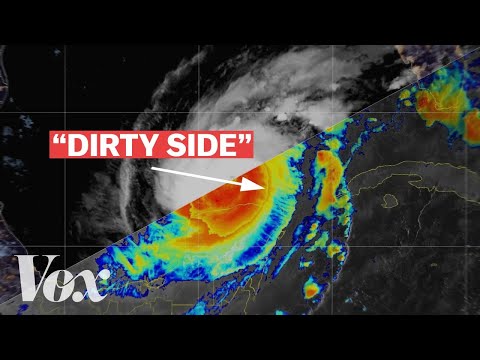
  • They don't show what happens here.

  • On the...

  • Dirty side.

  • Dirty side.

  • Dirty side.

  • You don't want to be on this side of a hurricane as it starts to make landfall.

  • Atlantic hurricanes like Milton, Helene, Katrina, ones in the Northern Hemisphere, rotate counterclockwise.

  • The center of a hurricane is the eye, a relatively calm column of air that scientists still don't fully understand.

  • Around that is the eye wall.

  • This is the strongest part of the storm, where the fastest winds and highest concentrations of moisture are.

  • Moving out from that are the rain bands, swirling winds and moisture that are very strong near the eye wall and weaken as they move to the outer edge of the hurricane.

  • From above, a hurricane looks pretty symmetrical.

  • But the energy isn't distributed equally.

  • Meteorologists divide a tropical cyclone into quadrants like this.

  • The right front, left front, left rear, and right rear.

  • It's the right side of the storm, and particularly the right front quadrant, that's often considered the most dangerous.

  • We call this the dirty side.

  • But what actually makes the dirty side so dangerous?

  • The dirty side of the storm is where the greatest winds, the greatest tornado risk, and crucially, the greatest storm surge and flooding usually occur.

  • That's because the winds here are moving in the same direction as the storm, combining their speeds, whereas the winds on the left side are moving in the opposite direction of the storm, which slows them down.

  • You can see the dirty side more clearly in radar images, like this one of Hurricane Katrina.

  • Look how much stronger the winds inside the rain bands to the right of the eye are compared to the left.

  • One important thing to note, though, is that the right and left side of a storm is relative to the direction the storm is heading.

  • So in a northern-moving storm like Hurricane Katrina was, the dirty side, on the right, was to the east.

  • But when Hurricane Laura was moving from east to west across the Atlantic in 2020, the forward-moving winds were more on top, to the north.

  • And for Milton, which was moving northeast, the right side of the storm was here, southeast of the eye.

  • The track of the storm is key.

  • Are you on the clean or the dirty side of the storm?

  • Some of the worst damage and threat to human life during hurricanes is from storm surge, when the forward-moving winds of an approaching hurricane push seawater toward the shore, which causes major flooding before the storm even hits.

  • These forecast storm surge maps from previous hurricanes show time and again that the most significant threat of storm surge is at the center of the storm, in the eyewall, and to its right, the dirty side.

  • And storm surge in coastal areas isn't the only way the dirty side can bring on huge amounts of rainfall and deadly flooding.

  • Helene's Path found western North Carolina sitting just to the right of its eye.

  • And the forward-moving winds in that part of the storm pushed warm moisture up the southern Appalachian Mountains, leading to historic rainfall and catastrophic flooding hundreds of miles inland.

  • Which is why these forecast diagrams emphasizing the cone of uncertainty, tracking where the storm will move to but omitting the wider potential impact areas, can be misleading when taken on their own, particularly for people living to the right of where the center of the storm will hit.

  • This is going to be where the potential impacts are still felt, even when Helene tracks within that forecast cone.

  • Just look at this graphic from the New York Times showing power outages in the aftermath of Helene, and you can see how much more devastating it is to be on the right side of the storm rather than the left.

  • Thankfully, a lot of meteorologists do provide warnings about the dirty side.

  • And some are starting to add context to storm tracking graphics to include potential impact zones.

  • Like this one from Hurricane Helene, where you can see the impact zone reaching farther to the right than to the left.

  • As climate change warms our oceans, we'll continue to see tropical storms gather enormous amounts of power quickly, leading to more catastrophic flooding, property damage, and threats to human life, both along coasts and inland.

  • And knowing which side of a future hurricane you're on will become even more essential.

  • Really quickly, before you go, we have something we're excited to tell you about.

  • Vox has launched a membership program.

  • It's the best way to support our journalism.

  • As a Vox member, you'll gain greater access to our award-winning newsroom and have your curiosity sparked by our new member-only benefits.

  • Please consider becoming a Vox member today.

  • Go to vox.com slash memberships to join.

When there's an Atlantic hurricane in the forecast, you see a lot of these diagrams.

Subtitles and vocabulary

Click the word to look it up Click the word to find further inforamtion about it